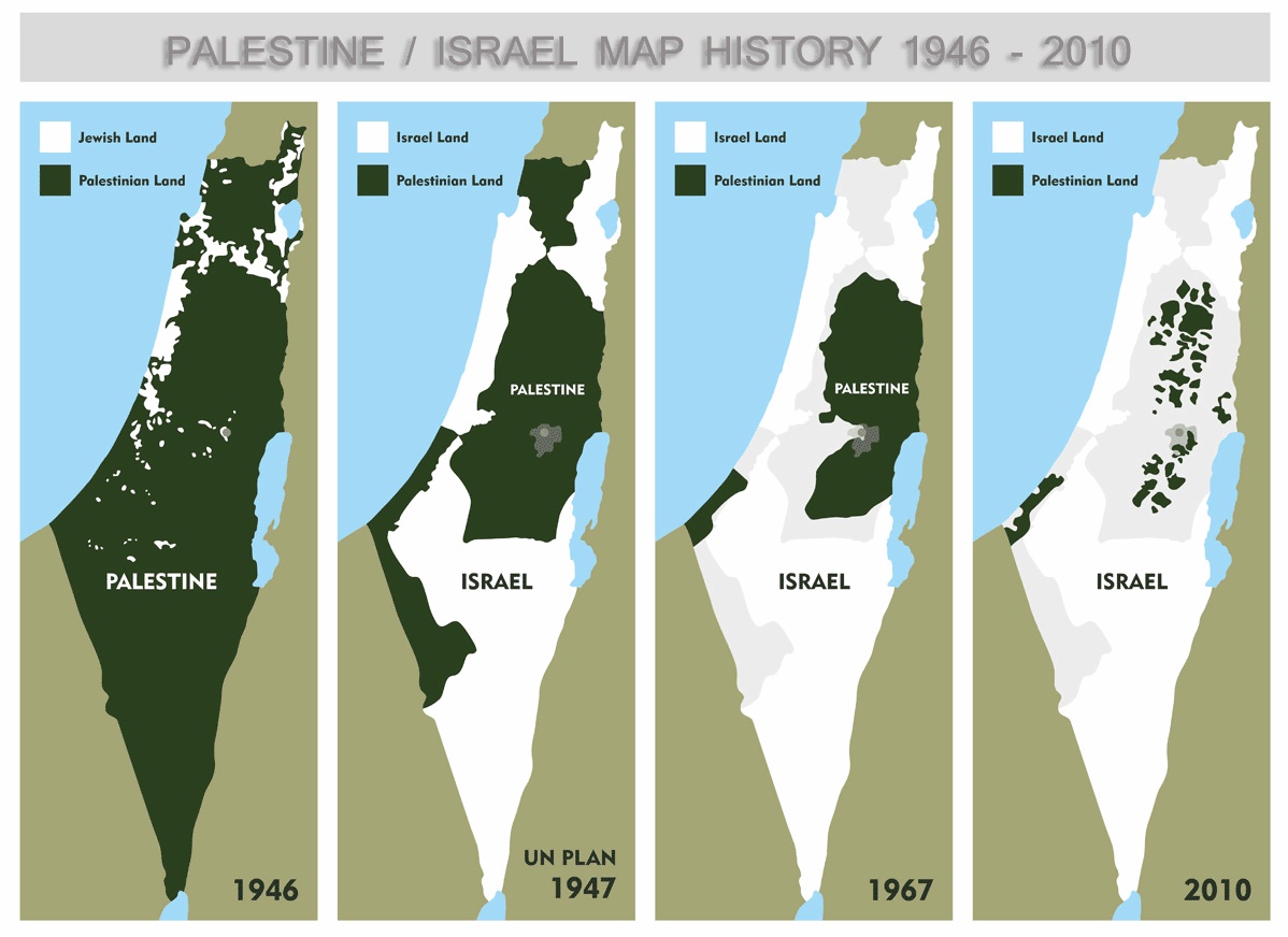
Map reading
Versions of this graphic have been
circulating for years, but now it seems to have gone viral on
Facebook. Does that make it a 'meme'? Whatever it is, it turns up on
my newsfeed every day or two as if it were some astonishing new
revelation, and largely from people who ought to know better.
I hate it.

Palestinians have never enjoyed
political control over any part of Palestine as this unfortunate
graphic suggests. Not under Ottoman rule or the British Mandate
('1946'); not under the abortive and downright bizarre UN partition
plan ('1947'); definitely not under Jordanian and Egyptian rule
('1967'); and absolutely not under Israeli occupation ('2010').
Furthermore, the graphic is consistent with the Oslo conceit that
'Palestinian' means those in 'Palestine', excluding, as always, the
Israeli and diaspora Palestinians.
The first panel purports to depict
'Palestinian land' and 'Jewish land'. Since all the land in 1946 was
under the control of the British Mandatory authorities, the only
thing it could be showing is land ownership. That's inconsistent
with the other three panels which clearly intend to show some form of
political control.
The second panel depicts the outlines
of the partition plan the UN General Assembly proposed in Resolution181, coincidentally, 65 years ago tomorrow. This is actually the most
useful panel insofar as it shows just how outlandish the
configuration of the Jewish state and the Arab state were to have
been, with the Arab state intersecting the Jewish state at two points. What it doesn't show, of course, is that
- UNGAR181 is just a request to the Security Council to implement its recommendations.
- There was an alternative and much more sensible proposal for a binational state under consideration at the time.
- The plan allocated some 55% of the land area to the Jewish state, even though only about 30% of the total population was Jewish.
- About 45% of the population of the Jewish state would have been non Jews.
- Of the 57 countries then comprising The International Community™, 33 voted in favour and 13 against, while 10 abstained and one was absent.
- The indigenous Palestinian population were never even consulted about how they felt about giving part of their land to European colonists.
- The plan was never implemented.
The Jewish partition is labelled
'Israel' and the Arab partition 'Palestine', although obviously,
there was no 'Israel' in 1947 and there is still no Palestine. In the
interests of pedantry, I note that the legend identifies the white
area as 'Israel [sic] land' in this and the next two panels.
In the third panel, labelled '1967',
shows the traditional outlines of what has come to be known
euphemistically as 'Israel proper', that is, within the armistice
lines drawn in 1949. If it purports to depict the situation prior to
6 June, then the areas labelled 'Palestine', i.e. the West Bank and
the Gaza Strip, were occupied by Jordan and Egypt, respectively and
were in no sense under Palestinian control. If after, then those
areas were occupied by Israel and should probably be shown in white.
Whoever compiled the graphic plainly intends to insinuate that these
are the areas that were allegedly to be allocated to the future
Palestinian state under the Oslo accords 27 years later. It's not
just anachronistic. It also invites the viewer to buy into the idea
that these are the areas over which Palestine was someday supposed to
be entitled to exercise control. In other words, it assumes a two
state 'solution', with all that that entails.
The last map shows the enclaves of
'Area A' in the West Bank that Oslo allocated to the administration
of the Palestine Authority (PA) that have gradually been isolated
from one another by Jewish only 'bypass roads' and other Israeli
incursions. The nature of PA administration is to act as a surrogate
for direct Israeli military control. By heading the graphic
'Palestinian loss of land' suggests that the areas marked 'Palestine'
are actually controlled by the quisling PA.
At the same time, it depicts the Gaza
Strip as mostly 'Palestinian land', with white patches showing the
Israeli settlements that were abandoned five years earlier.
What's really sad about the graphic is
that it could have been a useful resource if labelled accurately. The
last panel, in particular, shows the probable contours of the future
Palestinian state that always exists just over the horizon and that
will, if it should ever eventuate, satisfy demands for a two state
'solution' once and for all. The interminable 'negotiations' towards
this end will resume as soon as the intransigent PA abandons
unreasonable 'preconditions' not that Israel withdraw to the Green
Line depicted in the '1967' panel, but simply stop gobbling up more
and more of the West Bank while the negotiations proceed. It goes
without saying that Israeli preconditions - which preclude any
discussion of the entitlement of those expelled in 1948 and their
descendants to return; of Palestinian sovereignty over any part of
the greatly expanded and officially annexed area of greater Jerusalem
or 'the large settlement blocs'; of Palestinian control of their
borders, airspace, electromagnetic spectrum or aquifers; or of any
military force to defend 'Palestine' from their friendly neighbour –
offer no impediment to negotiation.


What the last three maps do show is the shrinking territory of the land proposed to nominally give the Palestinians sovereignty over in any "two state solution." Here it is obvious that the final map represents not a solution of two viable states, but of one Israeli state and one Palestinian bantustan.
ReplyDeleteThanks for your feedback, J. Otto.
ReplyDeleteIf that's what it said, it wouldn't be so problematic. The way the maps are labelled now is confusing and dishonest. One of the points, however, is to illustrate not just one, but several non contiguous bantustans.
One of these days, I'll get the hang of moderating comments.